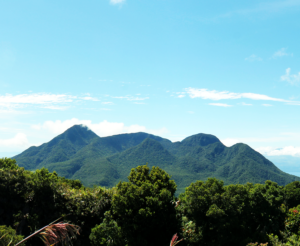
The Park is well-known for its refreshing climate, views,and waterfalls. It also has a catchment area for Touk Chhou, a major river flowing to Kampot. The Park is hilly in the north and east, with a plateau and escarpment in the west and southwest. The Park measures 140,000 hectares, and spans three southern provinces: Kampot, Kampong Spue and Preah Sihanouk, Cambodia. The area forms part of the Elephant Mountains, which is contiguous with the Cardamm Mountain range to the northeast. The southern boundary of the park is located less than one kilometer from the coastline of the Gulf of Thailand.
Biodiversity Data:
Biodiversity Data:
-
About Us
-
Flagship Initiatives
-
Programmes
-
News
-
Resources
- Biodiversity Conservation and Management of Protected Areas in ASEAN (BCAMP)
- Mobilising Stakeholders to Inform the Development of a Science-based Decision Support System for Coastal Wetlands in the ASEAN Region
- Understanding the Circumstances towards Achieving the Marine Protected Areas Target in the ASEAN Region
- Improving Biodiversity Conservation of Wetlands and Migratory Waterbirds in the ASEAN Region – Phase I
- Phase II of the Strategy of the CBD Secretariat on Protected Areas in East and Southeast Asian Countries (Small-scale Funding Agreement between the Convention on Biological Diversity and the ASEAN Centre for Biodiversity)
Menu
- Institutional Strengthening of the Biodiversity Sector in ASEAN I (ISB I)
- Institutional Strengthening of the Biodiversity Sector in ASEAN II (ISB II)
- Taxonomic Capacity Building on DNA Barcoding of Common Vascular Plants in the Tropics
- Development of the GTI Regional Action Plan for Southeast Asia 2016-2020 and Capacity Development on the Taxonomy of High Elevation Vascular Plants
Menu
Menu
- Capacity Building Towards Implementing the Nagoya Protocol on Access and Benefit Sharing, the City Biodiversity Index and the Strategic Plan on Biodiversity
- Biodiversity-based Products (BBP) as an Economic Source of the Improvement of Livelihoods and Biodiversity Protection
- Building capacity of countries in support of the development and implementation of National ABS Framework
- ABS Regional Capacity Building Project: Building Capacity for Regionally Harmonized National Processes for Implementing CBD Provisions on Access to Genetic Resources and Sharing of Benefits
- Promoting Sustainability and Market Values of Biodiversity-based Products (BBPs) through Sustainable Protocols and Participatory Certification Processes
- Small Grants Programme by the ASEAN Centre for Biodiversity


